Fremont County is one of the best destinations in Iowa in terms of species diversity. For several years the County Big Day record for Iowa of 171 species was held by a Fremont County team. The county has a good range of diverse habitats, with the most obvious absence being a large, permanent lake or reservoir. Otherwise, wetlands and forest habitats, both bottomland and upland, are available, as well as a large amount of edge habitat, the latter typical of much of Iowa.
If one wants to spend a full day birding in Fremont County, the following account outlines the places to visit and how to bird each place. I find that many locations can be easily found, but details on how to cover the location once there are scarce; a large state park or national wildlife refuge can be a bit bewildering to the first-time visitor!
Clearly, a full day’s birding in spring starts well before dawn with a search for nocturnal species. A good location for these is along the Spring Branch Loop of the Loess Hills National Scenic Byway, near Waubonsie State Park. From I-29 Exit 10 go east 4−5 miles on Highway 2 to the base of the loess hills. Turn north (left) onto Bluff Road (L44) and go about a mile to the first gravel road to the right, which has a Scenic Byway sign. Anywhere along the first mile or so is good for Whip-poor-will, Chuck-will’s-widow, American Woodcock, Great Horned Owl, and Barred Owl. A tape should entice an Eastern Screech-Owl to respond. The whips and chucks can easily be heard here at dusk also. As dawn breaks, Wild Turkey will be heard.
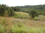 As light becomes suitable, return to Highway 2 and turn left (east) and go uphill; this wooded area is part of Waubonsie State Park (Figure 1). During spring and fall migration Waubonsie is good for migrant warblers, flycatchers, and thrushes, although the extensive habitat provides little concentration of these birds and finding them can be time-consuming (see Manti Park, later). Continue to the top of the hill and turn right onto a paved road to enter Waubonsie State Park (this road has recently been turned over to the county and is no longer a numbered highway). Park at the main parking lot at the top of the hill and bird the immediate area. This spot is good for Summer Tanager. Drive into and through the adjacent campground to the far end of the road (1) and quickly check the edge habitat here. Next, drive back towards the main parking area and you will see two paved roads leaving to the left. Take the second (closest to the parking lot) and follow it quite a distance to its end (2), stopping anywhere that looks good. Field Sparrows are here in the prairie areas on the westward slopes, as well as the expected range of upland woodland birds. Return to the main parking lot and turn right and then immediately right again and follow the road (please!) down a steep curve into an open grassy valley (3). This area is good for woodland birds including Summer Tanager and Blue-gray Gnatcatcher, as well as Eastern Phoebe nesting on the restroom building at the end of the road. The final destination at Waubonsie is back on Highway 2 near the bottom of the hill about a quarter-mile east of the junction with L44. There is a large pullout (4) on the north side of the road. Stop here and look into the ravine at the east end of the pullout for Louisiana Waterthrush, which can usually be heard singing here or on the other side of Highway 2. Another spot to check here is a footbridge (5) on the south side of Highway 2 about 200 yards downhill from the pullout. Walk to it (there is a poorly-defined, somewhat steep, short track to the bridge) and check again for Louisiana Waterthrush as well as other species.
The next stop is another good area for woodland passerines, and especially migrants. Manti Woods consists of about 35 acres of upland oak-hickory woodland in the eastern part of Fremont County near Shenandoah. It is a county park and its relatively small size qualifies it as a migrant trap. To get there, continue on Highway 2 eastward, crossing the junction with Highway 275. Continue east through Riverton; 4 miles east of Riverton turn left (north) onto M16 and continue straight north past the west edge of Farragut (a small section at the end of this road is unpaved) and turn right at a T-intersection. This returns you to M16 at its junction with eastbound J40, having bypassed Farragut. Continue east on J40; after about a mile there are some usually-wet, low-lying areas that should be checked for Bobolink, Eastern Meadowlark, and similar meadow species, even rails, depending on water conditions. Continue eastward to a point where the road veers left. To the right (east) is the entrance to Manti Park. Drive in and park at the top of the hill adjacent to a gate (there is a private residence close by). There is an excellent trail, which circumnavigates the park. The entire trail is good for upland woodland species, especially Tufted Titmouse, White-breasted Nuthatch, and woodpeckers. Migrant warblers are usually numerous here. One of the best spots is soon after the beginning of the trail (traveling clockwise) where the trail meets a stream (Fisher Creek). Manti Park retains reasonably good undergrowth, unusual in these times of runaway deer populations, and this helps augment the variety of passerines likely here. Sparrows are numerous here in March, April, and October.
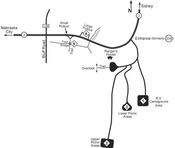
Figure 1. Waubonsie State Park birding areas: (1) RV campground area, (2) upper picnic areas, (3) lower picnic areas, (4) large pullout, (5) footbridge.
Once you have covered Waubonsie and Manti, you will be well into the morning and passerine activity will be declining in its intensity. Now is the time to head for wetlands, of which Fremont County has several. Of course, wetlands are variable in their suitability for birds depending on prevailing weather conditions. Forney Lake is a notorious example of this; it is directly dependent on the Missouri River water table, which currently is low, leaving the “lake” dry. In years of high water tables, Forney Lake is an outstanding destination and has produced a wide range of wetland birds and waterfowl, along with more than its fair share of rarities.
Another excellent wetland area is the Riverton Game Management Area (Figure 2), also somewhat dependent on water conditions, although there are water-level control facilities which allow management of water levels, primarily for fall waterfowl hunting. Access to the Riverton Area is difficult during fall hunting seasons (which now extend into January and February for Snow Geese), but is excellent in spring. The Riverton Area is also excellent for edge species such as Bell’s Vireo and in winter hosts a wide range of sparrows. Its evergreen shelter belts also host roosting Long-eared and occasionally Short-eared and Northern Saw-whet Owls.

Figure 2. Riverton Game management Area birding areas: (1) hunter check station, (2) levy, (3) main ditch at north end of refuge, (4) parking pullout, (5) brushy area.
To get to the Riverton Area from Manti Park, retrace your route to the town of Riverton. Continue west about 1.5 miles and turn north (right) onto a narrow paved road, which continues north on a levy. This is the southwest corner of the more than 600-acre Riverton Area. While driving north, check the woods and ditch to the right and the brushy wet areas to the left. After a little more than a mile, turn right to a small house-like building, the hunter check station (1). During nonhunting seasons, you can park here and walk eastward down onto the levy (2), which impounds the refuge part of Riverton Area. In wet years this is a nice lake, and in times of less moisture it can be outstanding for shorebirds. Almost anytime it is good for something! You should check the wooded areas en route, including the swamp areas before passing out onto the open levy. Prothonotary Warblers have nested here, and Tree Swallows are common. A telescope is essential here. In winter Bald Eagles are numerous and a surprising list of waterfowl species is here as late as Christmas Bird Count season. After covering this area from the levy, continue to the north on the gravel road. This road around the north end of the refuge includes many places where you should stop. Especially good is the crossing of a main ditch at the north end of the refuge (3) and the wet areas just to the east of the ditch. After the road turns south, there is a parking pullout (4) just before the road turns east again. You can walk out into the refuge (westward) from here to cover wetlands in the center of the area. These wetlands can be outstanding for shorebirds, rails, and bitterns given suitable water conditions. One of the best spots in the refuge for passerines is the brushy spring and swamp just up the hill from the pullout. Park adjacent to the brushy area (5) (there is a stream alongside the road on the south side) and check this area carefully. It is good any time of the year; the water is open year-round. Continuing in your car to the top of the hill you will see to the right an overlook from which you can get an overview of most the refuge. This overlook is useful for locating areas where water is present or where waterfowl are concentrating. A good hike from here takes you from the parking lot downhill to the left (south) through various hedgerow areas to the east end of the main levy impounding the refuge lake. The wetlands adjacent to the levy are productive at times, and the evergreen plantings visible on the hillside opposite and south of the overlook area are good for winter owl roosts. This hike takes some time, however, and may be a bit strenuous for some. This completes coverage of the Riverton Area, although die-hard winter listers might check feeders in the town of Riverton for House Finches and other winter possibilities.
To get to Forney Lake from Riverton, continue eastward from the overlook area out of the area and turn south onto the paved road. About a mile south of here is the east edge of Riverton. Turn right (west) and continue through Riverton and on west to the junction of Highways 2 and 275 (about 5 miles west of Riverton). Turn right (north) and follow Highway 275 to Sidney and on through Sidney (careful; navigating through Sidney is confusing!), continuing north on Highway 275. After about 5 miles, turn left at a well-marked intersection onto Highway 145 towards Thurman. Once in Thurman, you reach a stop sign; turn right (north) and you will reach another stop sign. Continue north along the paved Bluff Road (L44) and about two miles to a left (west) turn onto a gravel road. This road skirts the south side of Forney Lake. A telescope is essential here, too. Almost anything can show up here and in the adjacent brushy and riparian habitats depending on season and water conditions. There are a couple of islands near the north side of the lake where pelicans and cormorants congregate in season; other species can be scoped on these islands as well. When water conditions are suitable, Least Bittern and sometimes Common Moorhen are here; the bitterns are best observed in flight in August when they are feeding young and often fly about above the cattails. The Forney Lake area is often good for Great-tailed Grackle; check any blackbird flocks feeding in the fields south of the lake. The hedgerows at the southeast corner of the lake and around the hunter check station a short distance north of the gravel road on Bluff Road should be checked; this is an excellent place for Bell’s Vireo, and also for Harris’s Sparrows in winter. The grassy field at the southeast corner of the area (at the east end of the gravel road where it meets Bluff Road) is good for LeConte’s Sparrows in late September-October. Continuing westward on the gravel road adjacent to a house, there are excellent riparian and hedgerow habitats that can be explored. Walking out past the pump house at the east end of the large cottonwoods on the north side of the road opposite the house provides a useful vantage point for the west end of the lake.
A couple of other Fremont County specialties that should be looked for are Blue Grosbeak and Western Kingbird. Anywhere on the bottomlands west of I-29 is good; Western Kingbirds are found in deciduous trees around farmhouses and Blue Grosbeaks in brushy areas along drainage ditches. You should simply drive around until these birds are found. A good route to try can be reached by continuing west from Forney Lake on the gravel road, which shortly crosses railroad tracks and joins a paved road. Turn left (south) onto the paved road, which immediately crosses over I-29. Follow this paved road south about 6 miles to the Percival exit on I-29. Where the road crosses I-29 (to your left), turn right and head west about 2 miles, then south about 2 miles, east a mile, and south about 3 miles. Anywhere along this road is good for Western Kingbirds and Blue Grosbeaks, and there are some other worthwhile spots to check. A good area for Lark Sparrow is after the first 2 miles westward from the I-29 Percival interchange as you turn south. To the west is an interesting sandy area where Lark Sparrows are usually present.
At the south end of this route you will meet Highway 2 just on the Iowa side of the Missouri River bridge to Nebraska. This area is being developed by the local Soil and Water Conservation District as a wetland and should be outstanding in the future, given suitable water conditions. A Bald Eagle nest is visible from Highway 2 here. If one parks at the pullout at the small lake on the west side of Highway 2 about a mile into Iowa from the Missouri River bridge, a scan with binoculars (or even the naked eye) to the east will yield a large nest in dead cottonwoods. This nest has been active for several years, although a recent storm blew down the original nest and the birds moved to another tree nearby. Continuing northeastward on Highway 2 about a half mile from the lake you will see a signed intersection to Percival to the north. Turn left (north) here and immediately left again onto an abandoned paved road, old Highway 2. In wetter years this road is good for wetland species, but is worth checking at any time. Following it will return you to where you started, near the Missouri River bridge.
A great way to finish your day is to return to the Riverton Area hunter check station, walk out onto the levy, find a good spot with a view of shorebird habitat, and spend the waning hours of daylight watching the shorebirds arrive (they are diurnal migrants, of course). All sorts of strange things have flown by at this time of day (especially if you have been birding since 4.30 AM!).