Cerro Gordo County is a diverse area. It includes row crop farms, pastures, small wooded areas, meadows, a large lake, several marshes, and an area along the Shell Rock and Winnebago rivers where the river bottoms, woodlands, and layered limestone bluffs blend to make choice bird watching habitats. The Shellrock Greenbelt area, in particular, is noteworthy, because it is developed for recreational purposes and creates an oasis for migrant birds as well as nesting areas for breeding birds. This article provides an introduction to this area.
The extent of this greenbelt, from county line to county line, includes 770 acres of land that is accessible along the Shell Rock River. This corridor spans approximately 15 miles from the town of Nora Springs to the town of Plymouth and borders Cerro Gordo County’s east side. Some of these lands are hunted at various times of the year and some of the land is a preserve with hunting permanently prohibited. The main roads through and along the river are closed in winter and early spring; however, there are alternative routes for accessing these areas during the winter. I will point out the alternative routes after discussing the main route for each section.
This area hosts all kinds of migrant birds as well as local nesters. I will mention only a few species for each area but all could be found in most any section of the greenbelt. Considering the angle of the morning sun, it is generally best to bird from south to north during the summer. I have divided the area into eight sections, starting at the southern end (Figure 1).
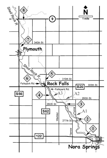
From Highway 122 at the west end of Nora Springs the entrance to the lower part of the greenbelt (1) will be found. This gravel road meanders through the first section of riparian woodlands. It is about a mile of road and about half way through this section there is an open grassy area. To the west are pines that have produced a number of owl species over the years. As the road curves and goes over a creek, the small woodland and marshy area on both sides has been productive especially for summer warblers, including American Redstarts and Chestnut-sided Warblers. Besides sparrows, migrant thrushes, flycatchers, and accipiters are particularly abundant in this section in spring.
The river road through Section l exits at the north end of the section onto 277th Street, which runs east/west. Turn right (east) and cross over the river to gain access to the next section on your left. The river road continues north along the east side of the river. This part is a wildlife preserve area (2) and hunting is not allowed. The road meanders through the wooded areas along the river. In the first part of the preserve, tanagers, cuckoos, many warbler species, and many of our resident birds can be seen. The road is rather rough and at times has pot holes, as the lower portion floods periodically. It climbs up and along the bluffs and at this point joins with the primitive campground area, although visitors can not drive into the camping area. That area has to be accessed by the alternative route.
Continuing north of this joining point with the campgrounds, among the trees on the right, there is a stand of pines that are mature and well over 60 feet tall. Despite the fact that this is not typical Long-eared Owl habitat, a Long-eared Owl or two will favor this spot in the winter, and will actually share it with a Great-Horned or Barred Owl, perhaps unknowingly, during the winter months.
Beyond this area, as you continue the drive north, you will encounter a service road that goes to the left. It is blocked to traffic, but walking this road will take you down to the river and to an area that was used for Boy Scout camping years ago. This area is good for warblers in spring. It also provides good looks at some of the limestone bluffs and at Cliff Swallows and their nests in summer. Exploring the area can produce owls, woodpeckers, thrushes, grosbeaks, and other residents.
Back at the road, continue north through the woodland area. In this section, much exploring can be done along the bluffs and in the river bottom areas. Brown Creepers are found in the winter; Red-headed Woodpeckers, tanagers, and other woodland birds are found in spring and fall. Sometimes in the dead of winter or the heat of mid-summer, we are lucky to find a bird here, and then other times we can’t keep up with the migrants or nesters as they forage in the area. The north end of this section has hosted Barred and Great Horned Owls at different times, Goshawks in the pines in the very north area, and eagles and hawks during migration. Toward the end of the route, you will encounter a creek. This is fordable with a four-wheel-drive vehicle or with a two-wheel-drive vehicle once the spring rains are done. You will exit out of the north end onto 290th Street.
Alternative 1 (A1): If the gate is closed at the entrance to Section 2, continue east on 277th Street to Yucca and make a left-hand turn. This road runs north along the eastern perimeter of the preserve, through the outer wooded area. Whip-poor-wills have been heard here in the spring. About one mile up the road there is an entrance on the left to the primitive campgrounds. Along this entrance road, the bushes and shrubs on the right have produced Bell’s Vireos several times and expected flycatcher species. Both Baltimore and Orchard Orioles nest in the area around the entrance. To the south along the entrance are pine trees that generally have in residence either a Great-horned Owl or a Barred Owl. Numerous times a Goshawk or other accipiters have used the pines in the winter. At the end of the entrance road there are restrooms and a picnic area. The oaks throughout the picnic area provide protected areas for tents and habitat for Red-headed Woodpeckers and flycatchers. Warblers can be found in this area in migration and entrance to the preserve woods is gained by walking west.
Leaving the camping area, continue along the alternative route by taking a left along Yucca Avenue and continuing until 290th Street. Turn left and drive west about three-quarters of a mile until you see the entrance to the third section on your right. This stretch of road has been good for Wild Turkey and Indigo Bunting. A Red-tailed Hawk or a Great-horned Owl is usually nesting in the oaks on the left side of the road. Shrikes also have been seen in this area.
Back at 290th Street, coming out of the preserve, travel left and before the bridge is the entrance to the next section. This is what we call the “hunted section” (3), because it is heavily hunted in every season that hunting is available. Despite this, it is perhaps our best section for birds. In this area, Townsend’s Solitaire, Northern Goshawk, Purple Finch, Long-eared Owl, and Bohemian Waxwing have been found in winter. In spring all species of warblers that migrate through the county can be found here. Thrushes, flycatchers — everyone wants to stop over and enjoy the cedars, pines, water, and open grass areas along the river. Accipiters, cuckoos, Cedar Waxwings, and orioles — it is the hot spot in the area. Just before the wooden bridge there is a path to the right that can be walked to enjoy the beauty of the area and to sight birds. This path is continuous all the way to 295th Street where you can cross the creek on the road and then loop back to the bridge where you started. Along the way are numerous stands of evergreens on both sides of the creek.
Continuing on the road north of the wooden bridge, the route winds through heavy cedars to an open area of grasses which contains several evergreen stands. A pasture adjoins the area where Short-eared Owls have been seen hunting, as well as Northern Harriers. Cuckoos, grosbeaks, and Bobolinks, a strange combination, can be found in this area.
The road comes out at 295th Street. The last section of this area always seems to have nesting Orchard Orioles in summer, Merlins resting in the trees during migration, and sparrows and farmland birds during summer along the east side that borders a farm field.
Alternative 2 (A2): Go east on 290th Street to Yucca and then north to the next intersection, which is 295th Street. Head west and along the road watch for hawks. Once you get to the greenbelt area, which is on the south, you can park and walk in on the path. It will take you to the wooden bridge on the inner road. Cross the bridge and go back along the opposite path. This is the same walk as mentioned above only done backwards. This walk is not too difficult, except in winter at −30-degree wind chill with six feet of snow, which is then a death march. Back at the car continue to Fallspark Road, watching for Shrikes and Northern Harriers along the road.
When you emerge from the hunted part of the greenbelt on 295th Street, you will head west by making a left turn, proceed across the bridge and take a right turn north along the west side of the Shell Rock River (4). This is the Wilkinson Park and campgrounds road that winds through the park grounds and comes out on S62 at the town of Rock Falls. Following this road will take you along the river over a covered bridge and past a restored prairie area. A Belted Kingfisher generally oversees the pond and orioles, bluebirds, and Bobolinks can be found here. Thrashers, catbirds, Yellow Warblers, and even a Carolina Wren have been seen along this road. The road continues to a camping area with restrooms and picnic tables. The oaks in this area have vireos and warblers moving through them in spring and fall. Going through a gate and onto S62, take a right turn north into town.
Alternative 3 (A3): Instead of emerging onto 295th Street, cross over 295th Street and continue north on Fallspark Road, which continues on the east side of the river as a good gravel road, but one that has little traffic. Spotted Sandpipers like the limestone edges that jut into the river. In about one mile, this will take you to B20 or 305th Street.
In the town of Rock Falls, there is only one main street. County Road S62 goes across the bridge and turns east down this main street, for one block. Here you will want to turn left and go north on Vine which is S62. At 310th Street the entrance to White Wildlife Area (5) is on the west. You can park along 310th Street and walk back to this area. The first part is a board walk over the marsh area. Both Virginia Rail and Sora are here spring and fall and Black and Yellow Rail have been seen here in the past. Yellow-headed Blackbirds nest here in the summer. Continue into the woods, where a path will take you around to a second board walk overlooking the marsh at the west end. In the woods are Wood Thrushes, once a White-eyed Vireo was seen here, and many warblers and vireos in spring and fall migration. Whip-poor-wills use the area in spring migration, too. This area can be a paradise for birders or it can be occasionally a bust, but it is always worth the walk around the area because it is so lush and beautiful. Also check out the Rock Falls Cemetery adjacent to the wildlife area on the south side. Crossbills, finches, and siskins can be lurking in the pines in winter.
From White Preserve, return south to Rock Falls on S62 joining with B20, which will take you across the Shell Rock River before heading west. In a short block, Fallspark Road (6) extends north along the west side of the river. With only occasional traffic to contend with on the gravel, you will not have to worry about stopping and looking at birds along this route. On the left are farm fields and some tree lots; on the right is the river. This route is particularly good in the spring when warblers are passing through. It has produced a Lazuli Bunting as well as Indigo Buntings, both oriole species, eagles that tend to sit along the river edge, and any accipiter that can be seen during migration. Northern Harriers, a Peregrine Falcon, and other hawks use the farm lands for hunting. At the area on the north end of the road, Brewer’s Blackbirds as well as Rusty’s are generally seen in the fall.
Fallspark road will emerge at the blacktop S56, where a right-hand turn leads north into the town of Plymouth. Watch the east side of the road as it goes by a curve in the river often used by waterfowl and geese as well as swans. Green-winged Teal, Common Mergansers, and Hooded Mergansers stop at this area as they migrate.
At the north end of the town of Plymouth, turn right into Strand Park (7), which is just prior to 340th Street. The park is on both the east and west side of the river and provides canoe access to the river. It is possible to look up and down the river quite a distance and to see waterfowl or hawks around the river. Surprisingly, Greater White-fronted Geese have been seen on this part of the river. Migrant songbirds use the dense thicket of trees. You can access the east side of the river by going on 340th Street, which is gravel.
One-half mile ahead on 340th Street is the Plymouth Pits Wildlife Area. The north side of this road is in Worth County, as are the pits. There is a nice walking area around the pits, although access to the river is limited.
Return to S56 and turn to the north. You are finished with Cerro Gordo County but you are two miles from Hwy 9 and a small prairie wetland area that is worth checking. County Road S56 stops at Hwy 9. Turn right and go east across the bridge to the parking lot on the south side for the area known as the Shell Rock River Wildlife Area (8). This prairie has wonderful wildflowers and the wetland beyond has been good for shorebirds if the water level isn’t too high when the birds come through. Buff-breasted Sandpipers and most of the common shorebirds have been seen in this area. American Bittern, Sora, and Virginia Rail, particularly in spring, can be heard calling. A variety of hawks have been seen hunting the open pastures and prairies. Sharp-tailed and Le Conte’s Sparrows like the marshy area during migration.
Thus ends the tour of the Shellrock Greenbelt and Preserve area. While I kept you mostly in Cerro Gordo County, you could continue further north into Worth County along the river and visit areas like the Two Waters Wildlife Area at Kensett. In fact, you could drive all the way to the Minnesota border along the Shell Rock River and find a number of choice birding areas to visit.
With an early start, a good day of birding along this route in the spring can be pure joy. There are always good birds to see here in the summer. Hawk watching in the fall has produced a variety of species. Winter birding along the Shell Rock River can produce some great finds to take away the winter blues.