 Woodbury County provides nature lovers with a multitude of opportunities to enjoy the outdoors. The Missouri and Big Sioux Rivers form the western border. The famous Loess Hills meander from north to south. Numerous oxbow lakes and ponds dot the county. And places like Stone Park, Bacon Creek, Brown’s Lake, and Snyder’s Bend have been well known to birders for years. Yet, history reminds us that humans have greatly changed our land and thus the birds and other wildlife that inhabit an area.
In pre-settlement times, the floodplain stretched westward from the Loess Hills to the hills on the west of the Missouri River. This low-lying area was blessed with frequent flooding. Spring brought rampaging water from the Missouri River and swollen tributaries from the Elk River down to the Soldier River that spilled onto the level, poorly drained plain, which assured the water crucial for this vast flatland to support tall grass prairies, sedge meadows, and cattail marshes. These palustrine wetlands, with their emergent vegetation were the stop over for countless migrating avian species as well as the breeding ground for waterfowl, wading birds, shorebirds, and passerines that depended on the wet prairies, meadows, or marshes.
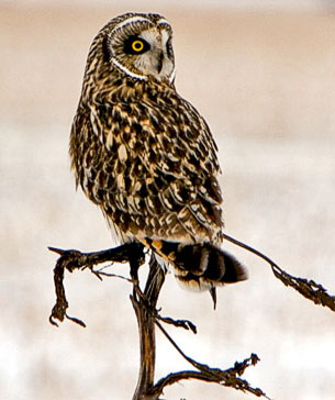
But settlement changed the landscape when the Missouri River was dammed and channelized, tributaries from the hills were ditched and diverted, and the floodplain was drained and cultivated. The wetlands disappeared, and along with them, the birds and other wildlife dependent on wetlands. Gone were a great majority of the nesting waterfowl, secretive rails and American Bittern, ground-nesting Northern Harrier, Short-eared Owl (Figure 1), Greater Prairie-Chicken, Bobolink, and numerous passerines.
Wetlands Complex Establishment
 Members of the Woodbury County Conservation Board (WCCB) sought to find a way to reestablish some wetland areas in the county. The project progressed fast in 1998 when a landowner placed his farm in the federal Wetland Reserve Program (WRP). Other adjacent landowners followed suit. Because none of the owners desired to retain ownership of their property, the WCCB was able to acquire title by residual value to a block of land a little over two square miles in area. The chance to create a major public wetland habitat was a reality. Most wetland development and enhancement work is planned and funded through WRP. In the case of the Owego Wetlands Complex, the WCCB sought and received approval to incorporate a higher-level development and management plan. Numerous partners were added to help make the project a showcase wetland for western Iowa. Most of the major developments have been completed and additional enhancement projects will be conducted as monies become available.
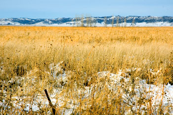
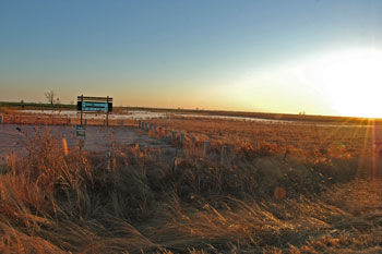
Thus, the Owego Wetlands Complex project was born (Figures 2 and 3). This complex is a 1,311-acre public area located approximately three miles northwest of Hornick, IA. in Woodbury County. The complex is comprised of primarily Luton clay soil, a heavy, wet hydric soil conducive to wetland development and difficult to cultivate. The area is named after the abandoned town site of Owego contained within its boundaries. It has been officially recognized as one of Iowa’s Important Birding Areas (IBAs).
During the last eight years, the WCCB has been establishing a variety of habitats throughout the complex including shrubs and small trees for winter habitat and food. In 1999, 200 acres were seeded with native warm season grasses and forbs recommended for wetland areas. Some acres were left to revegetate naturally. Approximately 178 acres were seeded with a native cool season mix for nesting potential. The complex contains three irrigation wells, 8.8 miles of low level dikes, 31.4 miles perimeter shoreline on excavations, 600+ acres of potential shallow flooding area, 35 acres of food plots, 25 acres of shrub plantings, 216 acres of cool season grass, 579 acres of warm season grasses/forbs and five public parking lot accesses.
Bird Species
At the request of the WCCB, the Loess Hills Audubon Society (LHAS) has been monitoring the site for bird species since October 2002. Since that date, LHAS members have compiled a list of 204 species that have been found at the site at least once. Some of the more notable discoveries include Golden Eagle, Peregrine Falcon, Prairie Falcon, Northern Bobwhite, Red Phalarope, Short-eared Owl, Blue Grosbeak, and most recent and possibly most unexpected was a juvenile Scissor-tailed Flycatcher. Some of the birds added in 2006 included White-faced Ibis, Forster’s Tern, Black and White Warbler, Red-necked Phalarope, Common Moorhen, American Avocet, Purple Martin, Semipalmated Sandpiper, Ruby-throated Hummingbird, Black-billed Cuckoo, Great-crested Flycatcher, Blackburnian Warbler, Olive-sided Flycatcher, Connecticut Warbler, Scarlet Tanager, Scissor-tailed Flycatcher, and Brewer’s Blackbird. More birders could likely enlarge the site list.
Spring migration brings multitudes of waterfowl, including most of our ducks and geese. Large concentrations of Northern Pintail and Blue-winged and Green-winged Teal can be seen. A great variety of shorebirds have been seen including Hudsonian and Marbled Godwit, American Golden and Black-bellied Plover, Dunlin, Willet, Black-crowned Night-Heron, American Avocet, Great and Cattle Egret, dowitchers, phalaropes, and sandpipers. The latter three can occur in large numbers. At the old town site, spring warblers, thrushes, and other songbirds can be seen. A pair of Great Horned Owls fledged three young there in early 2006. Fall and winter bring Northern Harrier, Short-eared Owl, Rough-legged Hawk, Northern Shrike, Merlin, longspurs, and a wide variety of sparrows.
How to Bird Owego
 The Owego Wetlands Complex is an easy yet rewarding place to bird (Figure 4). The most popular way to bird Owego is by vehicle because many of the species can be seen from the edge of the road. The roads are gravel and you can drive the whole perimeter. (Note of caution: 300th Street as you go east between Franklin Avenue and the canal can be quite tricky during periods of rain and melting snow.) As you drive the perimeter, watch and listen for Blue Grosbeak, Willow Flycatcher, and Bell’s Vireo in the thickets. Dickcissels are abundant in summer, and meadowlarks, Upland Sandpiper, Sedge and Marsh Wren, and Yellow-headed Blackbird can be seen in season. The road ditches normally contain water in the spring and can provide good views of American Bittern, Sora, and Virginia Rail. Bobolinks nest just east of the parking lot (Figure 4.B) on 290th Street, east of Franklin Avenue.
Park in the lots (Figure 4.A–E) and walk the edges of each section. Bird the woods on Garner Avenue or at the old town site. Hundreds of yards of Owego dikes can be traversed with decent shoes without getting wet. Depending on the season, these dikes may even be mowed for your convenience. For the more adventuresome, put on your mud boots and go tromping through (most) of the wetlands finding all kinds of things you would never see from the road. There are a couple of areas that require hip waders when the water levels are high. On one of the late spring counts, a Common Moorhen was discovered by a birder wearing waders.
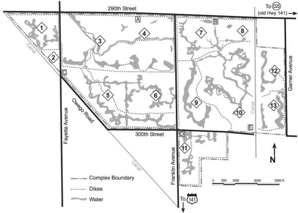
Figure 4. Map showing numbered birding sections (1–13), dikes, and parking lots (A–E) in Owego Wetlands Complex, Woodbury. See also Table 1.
Routes to Owego
Drive north three miles on Fayette Avenue from Hwy. 141 between Sloan and Hornick or drive east six miles from Salix on 280th Street to Fayette and one mile south to reach the site (Figure 4). The site is bordered on the north by 290th street. The three N/S roads are Fayette, Franklin, and Garner Avenues as you travel from west to east. The Owego town site and a portion of the complex are west of Fayette Avenue (Figure 4.2). Owego Road (runs southeast to 300th Street) and 300th Street borders the south except for a portion of the complex, which extends south of 300th Street and east of Franklin Avenue. One-half mile west of Fayette, 290th Street dead-ends, and three-fourths of a mile east of Franklin, 300th Street dead-ends.
Traffic is very minimal throughout the year. With the beautiful Loess Hills to the east and the sights and sounds of the birds, flowers, butterflies, and frogs in the wetlands, the area provides an enjoyable birding experience. Even in the winter solitude, the sight of a Rough-legged Hawk or a flock of longspurs can remind you of the busy migration season soon to come.
Species Locations
Blocks on the map (Figure 4) have been numbered (1 to 13) to enable locating certain species. The lists were generated based on our experience of how likely one might be to find a particular species in a given block. As a disclaimer: birds have wings, they are not always cooperative, and they do occasionally deliberately move about and pop up in areas we don’t expect to find them. Table 1 contains some of the less common species and the blocks in which they might be found. Northern Harriers may be hunting anywhere. Upland Sandpipers may be on Franklin Avenue near 300th Street on both sides. Short-eared Owls also may be seen in the fields north of 290th Street. Great Horned Owls may be perched midway up in any large tree. Sparrows in general occur in large numbers in the thickets and ditches along Fayette Avenue, Owego Road, 300th Street, and on Franklin Avenue along blocks 6 and 11.
Considerations
Keep in mind the seasons during which a particular bird would be most likely to be seen. The sun can really create havoc with your viewing pleasure. Drive or walk from east to west in the morning and vice versa in the afternoon. During winter, it is more productive to travel from south to north. Generally, birding is best in the morning but Owego can have good birds anytime. There may be lots of birds one day and few the next, particularly in the late fall and winter. But seldom do you go away without finding something interesting.
Visit Owego
Owego is a long trip for Mississippi River Iowans, but a visit is worth the travel. Or stop by for an hour or two as you travel through. Plan on visiting Owego before or after the Spring IOU meeting in Sioux City on 18–20 May 2007.
Report Sightings
It would be greatly appreciated if visitors would report their sightings and approximately where (block number, if possible), so we can continue to update the Owego Wetlands Complex records. Send reports to the IA-Birds listserv or to Jerry Von Ehwegen (jerryvonATpionetDOTnet).
Acknowledgements
Gratitude is expressed to the WCCB for the tremendous and continued effort to create and improve Owego. The success of Owego has spawned similar projects in other areas of the county. One can only imagine what the Missouri River floodplain must have been like 100 years ago with miles and miles of wetlands filled with millions of birds and other wildlife. We hope that there are opportunities to expand the size of Owego and/or add other tracts of similar habitat for the birds, animals, and people. Also, many thanks to Bill Huser for technical consultation pertaining to historical land and settlement perspectives and, of course, to everyone who has reported findings to the Loess Hills Audubon Society.
| Table 1. Owego Wetland Complex blocks (see Figure 4) in which less common bird species might be found |
| |
Block |
| Species |
1 |
2 |
3 |
4 |
5 |
6 |
7 |
8 |
9 |
10 |
11 |
12 |
13 |
| American Bittern |
|
|
|
X |
|
X |
X |
|
X |
|
X |
|
|
| White-faced Ibis |
|
|
|
X |
|
|
|
|
|
|
|
|
|
| Virginia Rail and Sora |
|
|
|
X |
|
X |
|
|
|
|
|
|
|
| Plovers (Blk-bel, Am Gold) |
|
|
|
X |
|
X |
|
|
|
|
|
|
|
| Red-necked Phalarope |
|
|
|
|
|
|
|
|
|
|
X |
|
|
| Yellow-billed Cuckoo |
|
|
|
|
|
|
|
|
|
|
X |
|
|
| E. Screech-Owl |
|
|
|
|
|
|
|
|
|
|
|
X |
X |
| Great Horned Owl |
|
X |
|
|
|
|
|
|
|
|
|
X |
|
| Short-eared Owl |
X |
|
X |
X |
X |
X |
X |
|
X |
X |
|
|
|
| Ruby-throated Hummingbird |
|
X |
|
|
|
|
X |
X |
|
|
|
X |
|
| Red-headed Woodpecker |
|
X |
|
|
|
|
|
|
|
|
|
X |
|
| Thrushes |
|
X |
|
|
|
|
|
|
|
|
|
X |
X |
| LeConte’s Sparrow |
|
|
|
|
|
X |
|
|
X |
X |
X |
|
|
| Nelson’s Sharp-tailed Spar. |
X |
|
|
|
|
X |
|
|
X |
X |
X |
|
|
| Blue Grosbeak |
|
|
|
|
|
|
|
|
X |
X |
X |
|
|
| Bobolink |
|
|
X |
|
|
|
|
X |
|
|
|
|
|