The Coralville Reservoir area in northern Johnson County is one of Eastern Iowa’s top birding locations. Coralville Reservoir is a 5,430-acre reservoir located north of Iowa City along the Iowa River valley. Several recreation areas managed by the U.S. Army Corps of Engineers offer access to the reservoir and the adjacent wooded bluffs. The upper flood basin of the reservoir, consisting of open water, wetlands, fields, and woodlands, is managed by the Iowa Department of Natural Resources as Hawkeye Wildlife Area. Lake Macbride State Park, featuring a man-made lake surrounded by wooded uplands and open areas, is located northeast of the reservoir. Macbride Nature Recreation Area, Swan Lake, Hanging Rock Woods, and Williams Prairie are other nearby areas which are visited by birders. The quality of the habitat for birds in many locations varies with the water level on the reservoir. Some of the roads are low-maintenance and at times are impassable due to mud, snow, or high water. Most of the public areas are open to hunting during season.
During migration, the area supports large numbers of ducks and geese, as well as loons, grebes, pelicans, cormorants, herons, gulls, and terns. When water levels are low or receding, extensive mudflats attract large numbers of migrating shorebirds. All of the regular Iowa shorebirds have been seen, including Piping Plover, American Avocet, Willet, Hudsonian and Marbled godwits, Ruddy Turnstone, Sanderling, Western, Baird’s, and Buff-breasted sandpipers, and Red-necked Phalarope. Migrating and wintering raptors are frequently seen. Long-eared, Short-eared, and Northern Saw-whet owls are usually found each winter. Wooded areas provide habitat for migrating and nesting warblers and other passerines. Weedy fields and hedgerows provide excellent places to find sparrows during migration.
 Rare summer residents, most of which probably nest, include Double-crested Cormorant, Cooper’s Hawk, Pileated Woodpecker, Acadian Flycatcher, Brown Creeper, Bell’s Vireo, and Yellow-throated, Prairie, Cerulean, Prothonotary, and Kentucky warblers. Rarities seen in recent years include Snowy Egret, Little Blue Heron, Yellow-crowned Night-Heron, White Ibis, Cinnamon Teal, Oldsquaw, Mississippi Kite, Northern Goshawk, Yellow Rail, Whimbrel, Sharp-tailed and Curlew sandpipers, Ruff, Red Phalarope, California, Lesser Black-backed, Glaucous, and Sabine’s gulls, Black-legged Kittiwake, Least Tern, Snowy Owl, Black-throated Blue and Worm-eating warblers, Western Tanager, Black-headed Grosbeak, Spotted Towhee, Nelson’s Sharp-tailed Sparrow, and Hoary Redpoll.
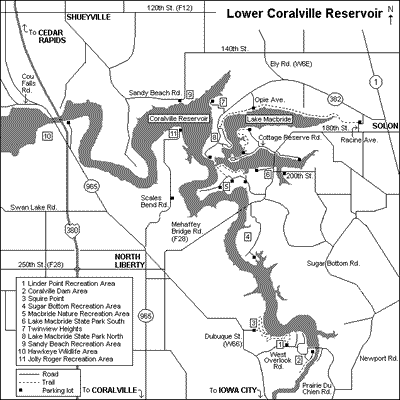
Coralville Dam Area: Begin the tour at the intersection of Dubuque Street (County Road W66) and Interstate 80 in Iowa City (I-80, Exit 244). Follow Dubuque Street north for 2.6 miles, then turn right on West Overlook Road and proceed 0.6 mile to a parking lot on the left at Linder Point Recreation Area. From the trailhead here, several miles of trails wind along the forested bluffs overlooking the reservoir. Cerulean Warblers are sometimes found in this area during the breeding season. Continue east on West Overlook Road and follow the signs to the beach above the dam. This area is crowded with visitors in summer and closed to vehicles in winter, but during early spring and late fall gulls often congregate here, and diving ducks and grebes may be present. Return to West Overlook Road and follow the signs to Tailwater West below the dam where, in late fall and early spring, gulls may be seen flying over the water. The open water below the dam in winter attracts small numbers of waterfowl and Bald Eagles, which may be viewed from the road or from the trail which leads south along the river. Pileated Woodpeckers have been seen occasionally along the trail. Drive across the dam to the East Overlook area. The short paved trail on the south side of the road leads to a bird blind where common woodland birds may be observed visiting feeders. At the Coralville Lake Visitor Center, located on the north side of the road, you may obtain a map of the area and view interpretive displays. When you have finished exploring the dam area, return to Dubuque Street and turn right. In 0.9 mile a turnoff on the right leads to the Squire Point trailhead, which connects to the Linder Point trails. Continue on to North Liberty and turn right on Front Street (2.4 miles), which becomes Mehaffey Bridge Road (County Road F28) outside the city limits.
Sugar Bottom Recreation Area: Just past Mehaffey Bridge (3.0 miles), pull over on the wide shoulder and scan the reservoir for gulls, terns, ducks, and other water birds. Cliff Swallows nest under the bridge. The hillside on the right just beyond the entrance to Sugar Bottom Recreation Area is a favored spot for watching the fall raptor migration. Broad-winged and Cooper’s Hawks peak in mid- to late September, while Sharp-shinned Hawks are commonly seen from mid-September to mid-October. Ospreys are also regular migrants during September and early October, and an occasional Peregrine Falcon is seen. The road into Sugar Bottom Recreation Area, which is closed to vehicles in winter, leads 1.6 miles to a campground and beach, which offers a view of the reservoir. Snow Buntings and American Pipits have been found on the beach in late fall. Use caution in this area during hunting season.
Macbride Nature Recreation Area: Continue north on Mehaffey Bridge Road 0.6 mile to Macbride Nature Recreation Area on the left. This 480-acre tract managed by the University of Iowa is home to the Macbride Raptor Center. Hours are 6:00 a.m. to 9:00 p.m. April through October and 9:00 a.m. to 6:00 p.m. November through March. The nine miles of trails offer excellent opportunities for viewing warblers and other passerines during summer and migration. In general the areas north of the entrance road are heavily wooded, while the areas south of the road are a mosaic of woodlands, conifer plantings, open fields, and restored prairie. Stop at the information display near the entrance for a map of the area.
A large brushy hillside is located on the right side of the road 0.5 mile from the entrance. Blue-winged Warblers may be heard here during the nesting season, and Prairie Warblers have been observed here on two occasions. To reach one of the best trails in the area for nesting woodland birds, especially warblers, park at the large parking lot on the left side of the road 0.8 mile from the entrance. On foot, follow the sign to the sailing club north of the main road. Continue past the sailing club, and just before reaching the dock, take the trailhead on the left into the woods. This trail winds through mature oak – hickory forest and eventually returns to the main road. American Redstarts are abundant along the trail in summer, and Ovenbirds, Scarlet Tanagers and Blue-gray Gnatcatchers are common summer residents. This is the best place in the area to find nesting Cerulean Warblers, which can be located by listening for the buzzy songs of the males high in the treetops. Prothonotary Warblers sometimes nest in snags near the water’s edge. Louisiana Waterthrush, Acadian Flycatcher, and Worm-eating Warbler have been found in summer, but are not seen regularly.
Another area worth visiting here is the Macbride Raptor Center. Follow the entrance road to the main parking lot, 1.3 miles from the entrance. Turn right onto a gravel road (closed to vehicles in winter) and continue 0.3 mile to a parking area. From here it is a short walk to the center. A joint project of the University of Iowa and Kirkwood Community College, the Macbride Raptor Project provides rehabilitation for injured and orphaned birds of prey and presents educational programs to the public. Many permanently disabled eagles, hawks, falcons, and owls are on display year-round at the center. There is also a bird blind nearby, where common woodland birds may be observed at close range visiting the well-stocked feeders.
Lake Macbride State Park: After leaving Macbride Nature Recreation Area, continue north on Mehaffey Bridge Road 0.5 mile to the south unit of Lake Macbride State Park. This 2,180-acre park features a large man-made lake and miles of hiking trails through mature forest, brushy fields, and restored prairie. There are many parking areas from which to view the lake. Diving ducks, gulls, and other water birds can be found on the lake in early spring and late fall. Common Loons, Horned Grebes, Bonaparte’s Gulls, and Common, Red-breasted, and Hooded mergansers are regular migrants, and Eared Grebes are sometimes seen. Ospreys are often seen patrolling the lake in April through May and again in September and October.
Turn right at 200th Street and proceed over a small arm of the lake to a parking lot (0.3 mile). The shallow backwaters to the south sometimes attract dabbling ducks, shorebirds, and herons during spring and fall, and Wood Ducks are often seen. Return to Mehaffey Bridge Road and turn right. Continue 0.2 mile and turn left onto a dead-end road which parallels the south shore of the lake. This road offers views of the lake, and a backwater where herons and Wood Ducks can be found is located on the south side of the road. Back on Mehaffey Bridge Road, continue across the causeway over the lake to a "T" intersection. Turn left and proceed 0.3 mile on Cottage Reserve Road, then turn right and continue 0.5 mile to a parking lot. The boat ramp here provides a nice view of the north arm of the lake. A sailboat storage enclosure is located west of the parking lot. Prairie Warblers have been found on the brushy hillside south of this enclosure every summer since 1994. The hillside is very densely overgrown, and patience and determination are needed to view the birds. They are most easily located between mid-May and mid-July, when the male Prairie Warbler repeats his ascending, buzzy "zee-zee-zee" song. Occasionally the birds are observed farther south on the east side of the road where there is much less brushy growth. Nesting Blue-winged Warblers are often present south of the enclosure as well, and Long-eared and Northern Saw-whet owls are sometimes found during winter in the conifer grove along the west side of the road.
Return to Cottage Reserve Road and turn right. Proceed 0.4 mile, and before reaching the stone gates at the entrance to the residential area, veer right and continue a short distance to a parking lot. A few Yellow-throated Warblers nest in this area, and are sometimes found in the large sycamore trees near the entrance gates. More often, however, they are found near two white pine groves along the trail to the north. The trail leads 1.5 miles to the parking lot near the sailboat storage enclosure. Cerulean Warblers are sometimes heard along the trail, and Northern Parulas have been found infrequently in the sycamores. Ruby-throated Hummingbirds and Purple Martins are often seen near the residential area.
Return to the "T" intersection with Mehaffey Bridge Road and continue straight (east) 0.1 mile to a road on the right. This road parallels the shore and offers views of the lake. Continue east on Mehaffey Bridge Road. At the outskirts of Solon (2.3 miles), turn left at Racine Avenue and proceed 0.3 mile, where a parking lot marks the east end of a 5-mile recreational trail from Solon to the north unit of Lake Macbride State Park. For most of its length the trail follows the north shore of the lake and passes through brushy fields, small woodlots, conifer plantings, and mature woodland. Some of the interesting breeding birds which can be found along the trail include Bell’s Vireos, Orchard Orioles, Yellow Warblers, American Redstarts, and Green Herons. In October, the brushy areas along the east end of the trail can be excellent for sparrows, including Harris’s and Lincoln’s.
Continue into Solon; turn left at Chabal Street, proceed two blocks to Highway 382, and turn left. Drive west 1.1 miles, where two ponds are located on the south side of the highway. Be sure to pull completely off the highway onto the shoulder. During spring, these ponds are a good place to observe marsh ducks. Continue west 1.8 miles and turn left onto Opie Avenue. This dead-end road leads south to a parking lot which offers a view of the lake and another access to the Solon – Lake Macbride recreational trail. Return to Highway 382 and drive west another 1.1 miles; turn right into the Twinview Heights subdivision and then immediately make another right turn onto Meadow Drive. Follow Meadow Drive as it turns into Lakeside Drive, and at Wildwood Drive (0.5 mile) turn right onto a gravel road. At the fork, turn left and follow the road a short distance to a boat ramp which provides an expansive view of the reservoir. In early spring and late fall this can be an excellent place for viewing Bald Eagles, diving ducks, grebes, loons, gulls, and other water birds.
Return to Highway 382, turn right (south) and proceed to the north unit of Lake Macbride State Park (0.4 mile). The west end of the Solon – Lake Macbride recreational trail is located just inside the entrance to the park. Stop at the information kiosk just ahead to pick up a map of the park. The north unit of the park is heavily wooded and features several hiking trails. Typical breeding birds of the mature oak-hickory woodland here include Wood Thrush, Scarlet Tanager, and Ovenbird. Yellow-throated Warbler and Northern Parula have been found occasionally in the row of sycamores along the road to the beach. The Coralville Reservoir boat ramp offers a view of the reservoir.
Sandy Beach Recreation Area: After exploring the park, return to Highway 382 and backtrack towards Solon. Turn left at Ely Road (County Road W6E, 2.1 miles) and proceed north. Turn left at 140th Street (1.0 mile), and continue west and then south on Sandy Beach Road to Sandy Beach Recreation Area (3.3 miles). The wide shoulder of the road and the parking lot at the beach offer excellent vantage points for viewing the reservoir. In spring and fall during times of low water, there may be mudflats which attract shorebirds. In September, marshy vegetation may be checked for American Bitterns and Nelson’s Sharp-tailed and LeConte’s sparrows. Continue northwest on Sandy Beach Road to Shueyville (4.3 miles). At the four-way stop, turn left onto 120th Street (County Road F12) and drive west to Highway 965 (1.5 miles). Turn left and drive south 2.4 miles to Cou Falls Road.
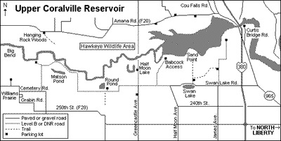 Hawkeye Wildlife Area: Hawkeye Wildlife Area is a 13,510-acre federal area that is managed by the Iowa Department of Natural Resources. It encompasses the upper flood basin of the reservoir, extending for nine miles from Highway 965 almost to the Johnson – Iowa County line. To reach the north side of the wildlife area, turn right onto Cou Falls Road, and when it veers right after 0.2 mile, bear left onto Amana Road (County Road F20). There are many parking areas along Amana Road from which you may view the wetland area to the south or explore the wooded ridge to the north. Drive west on Amana Road 0.3 mile to a parking lot on the left, across from the Hawkeye Wildlife Area headquarters. The parking lot offers a view of the vast floodplain to the south. Waterbirds and raptors are often seen from here but are usually very far away.
Continue 0.8 mile to another parking lot on the right. North of the parking lot over a small rise is a clearing where American Woodcocks display at dusk and dawn during April and May. Just east of the parking lot is a grove of conifers where Northern Saw-whet Owls are often found during winter. Search the branches carefully and check the ground for pellets and droppings. Once located, saw-whet owls are normally quite tame and may be viewed at close range.
Continue west 0.4 mile to another parking lot on the south side of the road. Except in very wet years, Savannah Sparrows nest in the vegetation south of the road here. This is a good location to listen for Whip-poor-wills calling at dusk from the wooded bluffs during the late spring and summer.
Continue along Amana Road 0.7 mile to Greencastle Avenue. Northwest of this intersection on the hillside is a small grove of cedars which sometimes attracts wintering Northern Saw-whet Owls.
Hanging Rock Woods: Continue west on Amana Road 4.1 miles to a parking lot on the left. The area south of the road is a large wooded ridge which juts out into the surrounding bottomland. The southern tip of the ridge is private land, but the northern part of the ridge and most of the surrounding bottomland is public. A trail leads through the woods along the ridge top. This is an excellent location for spring warblers, vireos, thrushes, and other migrants. During the summer, Cerulean and Kentucky warblers can be found, and Prothonotary Warbler, Pileated Woodpecker, Acadian Flycatcher, and Brown Creeper have been found in the bottomland forest at the end of the ridge.
Return to Highway 965 and turn right (south). Where the highway crosses the reservoir (0.5 mile), you may want to pull off onto the wide shoulder and scope the area to the west. Continue south 1.8 miles to Curtis Bridge Road on the left. The boat ramp at the end of Curtis Bridge Road (0.8 mile) offers another view of the reservoir. Continue south on Highway 965 1.6 miles, then turn right onto Swan Lake Road.
James Avenue: To reach the south side of Hawkeye Wildlife Area, drive west 1.3 miles and turn right onto James Avenue. The buildings on the right are the former wildlife area headquarters. The plantings and the small creek behind the buildings attract warblers and other passerines during migration. Continue to the second parking area on the left (0.5 mile). From late April to early May and during October, the hedgerows along the road and in the nearby fields can be excellent for migrating sparrows, including Harris’s, Lincoln’s, White-crowned, and rarely Clay-colored. A trail leads west from the parking lot past several ponds and a marsh to just north of the Sand Point parking lot. James Avenue continues 1.5 miles through fields and timber to a parking lot, where you may park and walk west for a view of the reservoir.
Swan Lake: Return to Swan Lake Road and proceed west 0.9 mile to a pullout on the left overlooking Swan Lake. During migration, scan the lake for waterfowl, grebes, shorebirds, terns, and all six swallow species.
Sand Point: Just past the Swan Lake pullout, turn right onto the Sand Point access road and continue 0.1 mile to a parking area on the right. East of the parking lot is a small pond which harbors nesting Wood Ducks. The woodlot and plantings between Swan Lake Road and this parking lot can be good for warblers and other passerines during migration. The Sand Point road is closed to vehicles beyond the parking lot, but you may walk on the road approximately one mile to Sand Point. (This area is a wildlife refuge and is closed to the public from 10 September to 25 December.) A spotting scope and rubber boots are recommended. During the walk you may hear resident Lark Sparrows singing from the trees and Horned Larks in the fields. Farther out near the point, Savannah Sparrows nest in the low vegetation and American Pipits may be found during migration. Sand Point itself provides a panoramic view of the area, but the quality of the birding depends on the water level. In very wet years the entire area may be under water, but when the water is low or receding, typically in late summer, mudflats provide habitat for thousands of shorebirds. In late summer and early fall, you should also see large numbers of American White Pelicans, Double-crested Cormorants, Great Blue Herons, and Great Egrets, as well as various gulls, terns, and ducks.
Return to Swan Lake Road, turn right, and continue 0.8 mile to Half Moon Avenue. A good location for Eastern Screech-owls is located along Half Moon Avenue 0.2 mile to the left. To hear the owls, park alongside the road before dawn or after dusk and softly play a tape of the screech-owl’s call. The tape may also rouse nearby Barred or Great-horned owls.
Babcock Access: Past Half Moon Avenue, Swan Lake Road is dirt for the next 1.1 miles and may be impassable during wet weather. (If so, take a detour by driving south on Half Moon Avenue, then west on 250th Street, then north on Greencastle Avenue back to Swan Lake Road.) If the road is passable, continue west for 0.4 mile, and then turn right onto the Babcock access road. Continue 1.0 mile to a parking lot at the end of the road. When the water level is right, this is the single best birding location on the Coralville Reservoir. You should see many of the same species that are visible from Sand Point. Resident cormorants are present from spring to fall, and some American White Pelicans linger through the summer. Dead trees to the north and west provide roosting sites for many waterbirds and raptors. During late fall and early spring this is a good place to view Bald Eagles. In late summer a walk eastwards towards Sand Point may provide views of many shorebirds; rubber boots and a spotting scope are recommended.
Greencastle Avenue: Return to Swan Lake Road and continue west for 0.7 mile to Greencastle Avenue. Turn right and drive north 0.6 mile to a parking lot on the left. The parking lot overlooks Half Moon Lake (also called Crescent Pond), which can be excellent for waterfowl and shorebirds during migration. In March, Greater White-fronted Geese and many species of ducks can be found here. This is an excellent place to view raptors, including Northern Harriers, Rough-legged Hawks, and Bald Eagles from late fall through early spring. Peregrine Falcons and Merlins are sometimes seen in this area during migration when shorebirds are present. In spring the cattails on both sides of the road may harbor marsh birds such as American Bittern, Sora, Virginia Rail, and Marsh Wren. You can continue north on Greencastle Avenue 0.1 mile to a "Road Closed" sign.
Turn around and drive south on Greencastle Avenue 1.0 mile (past Swan Lake Road), where in most years there is a small pond divided by the road. This is called the Gunclub Pond, and you should see teal and Northern Shovelers here during spring, and Wood Ducks and Green Herons during the summer months. Continue 0.1 mile to a parking lot on the right. In the area to the west of this parking lot are many scattered Eastern Red Cedar trees. During the winter months these cedars often harbor roosting Long-eared Owls and, occasionally, Short-eared Owls. To locate the owls, check the ground beneath the cedars for pellets and white wash. Often the owls are not seen until they flush from the trees and fly a short distance away. Please keep disturbance to the owls at a minimum, and be cautious in this area during deer hunting season.
Round Pond: Return to Swan Lake Road, turn left and drive west. This low-maintenance gravel road, which is maintained by the DNR, continues more than six miles through a mixture of cultivated fields, wet areas, and small woodlots. In fall there are many weedy areas along the road to check for sparrows. Round Pond (1.5 miles) is usually not very productive for birding, but may attract a few ducks and shorebirds during spring migration. Just past the Round Pond access road, a trail leads south to a grove, creek, and two ponds. This is a nice area to walk for sparrows, warblers, and other migrants, and the ponds may harbor ducks and other marsh birds. Continue driving west. When you arrive at the "T" intersection (3.4 miles) turn right and drive 0.1 mile to a parking lot. During the early summer you may wish to search for nesting birds in the bottomland forest to the west. Walking can be difficult, but birds that have been found include Pileated Woodpecker, Brown Creeper, and Prothonotary and Yellow-throated warblers, the latter in the sycamore trees several hundred yards northwest of the parking lot.
Return to the intersection, turn right and continue 1.2 miles to Cemetery Road. Along the way, listen for Lark Sparrows, Savannah Sparrows, and Dickcissels. The extensive grassy fields along this road sometimes harbor wintering Short-eared Owls, which are best viewed from Cemetery Road at dawn or dusk.
Williams Prairie: At Cemetery Road, turn right and drive west 0.8 mile to Grabin Road. Turn left and drive 0.2 mile to Williams Prairie, a small wet prairie on the left owned by The Nature Conservancy. In some years, Sedge Wrens have nested here. Continue on Grabin Road 1.3 miles as it zig-zags south and east to 250th Street (County Road F28). Drive east 9.5 miles to Highway 965 in North Liberty.
Jolly Roger Recreation Area: Turn left and drive north 0.5 mile to Scales Bend Road. Turn right and proceed north 2.0 miles, where an unmarked drive and parking lot are located to the right. This privately-owned woodland, known as Sherwood Forest, adjoins public property along the lakeshore. The owners welcome hikers and maintain a network of trails. Pileated Woodpecker, Acadian Flycatcher, Veery, and Cerulean Warbler have been found here during summer, but should not be expected on most visits. Continue north on Scales Bend Road 1.1 miles to where the road makes a sharp right turn. The land to the west and north of the road here is public, and the brushy hedgerows can be productive for migrant sparrows and other land birds in spring and fall. Continue 0.4 mile to the Jolly Roger Recreation Area campground and marina. The boat ramp here provides another view of the reservoir. When you have finished scoping the lake, return to Highway 965 and continue south. Turn left at Zeller Street in North Liberty (1.0 mile), then right at Dubuque Street (0.8 mile), and drive 5.3 miles to return to the starting point at the intersection of Dubuque Street and Interstate 80.